


We offer full-service GIS support as your contracted GIS department. We handle everything from data management and map production to spatial analysis and reporting, giving you expert capabilities without the overhead of an in-house team.
Our GIS service packages give you access to a set number of professional GIS support - perfect for zoning updates, utility mapping, map hosting, custom applications, and more. We provide geospatial solutions tailored to your needs.
What is Included?
We offer different packages based on the needs of your organization. Each of our GIS Department packages includes a set number of monthly service hours, plus powerful tools to support your staff and community. All packages come with responsive support, web-based mapping tools, and a strategic approach to help your local government thrive.
Starter Package
Perfect for local governments just beginning their GIS journey. This package offers a simple, accessible way to start using GIS without the complexity, giving you reliable support, easy-to-use public maps, and a strong foundation to build on.
96 hours of GIS work per year (average of 8 hours per month)
2 free web map applications created during the setup period (no hours used)
No user accounts - public maps only
Standard Package
Designed for local governments ready to take their GIS to the next level. This package offers expanded support, more flexibility, and access to both public and internal mapping tools. With multiple custom web apps and user accounts included, your team can view and edit data with ease, making collaboration and decision-making even smarter.
192 hours of GIS work per year (average of 16 hours per month)
4 free web map applications created during the setup period (no hours used)
Public and Internal only maps
5 Viewer accounts, 1 Editor account
Details
We act as your on-call GIS department.
Each GIS package includes a set number of hours per year that can be used however you need—whether it's updating existing maps, creating new ones, analyzing data, or tackling special projects. You’ll also receive a set of custom web maps created during the setup phase, and the time spent building those doesn’t count against your annual hours.
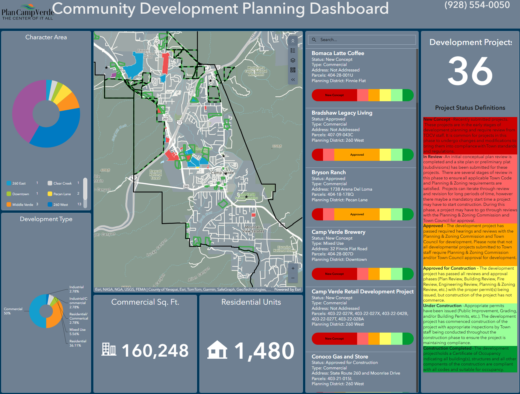
We offer two types of maps: public and private.
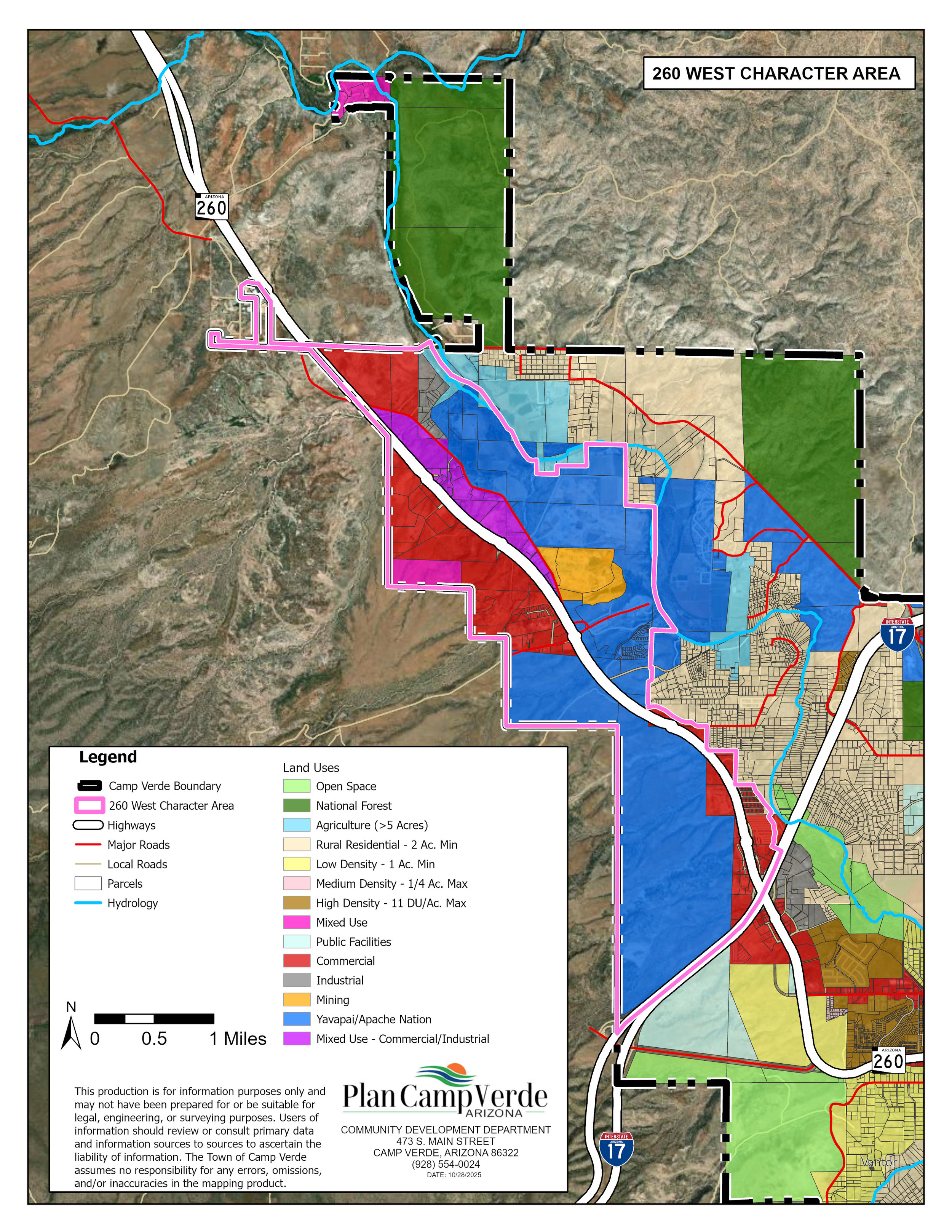
Public maps are accessible to anyone without a login and are ideal for sharing general information like zoning, parks, trails, or parcel data with your community.
Private maps require user accounts and are restricted to authorized personnel. These are perfect for sensitive data—like water infrastructure or fiber networks—ensuring secure access for internal use while keeping critical information protected from public view.
Additional User accounts
Viewer: A Viewer can look at maps and dashboards but can’t change anything. It’s perfect for staff who just need to access information—like viewing sensitive information—without editing or adding data.
Editor: An Editor can do everything a Viewer can, plus they can update and add data to maps. This is great for users who need to keep information current, like updating asset locations, editing attributes, or managing map layers.
Mobile Worker: A Mobile Worker account is designed for field use. These users can collect data on the go using tablets or mobile devices. They can features, fill out forms, take photos, and sync everything back to your GIS system in real time.
Full Service Package
Built for local governments ready to fully integrate GIS into their operations. This package offers the highest level of support, with advanced mapping tools, both public and internal access, and a dedicated GIS domain for your organization. With enhanced user access and mobile capabilities, your team can view, edit, and collect data in the field, making GIS a seamless part of your daily workflow.
288 hours of GIS work per year (average of 24 hours per month)
5 free web map applications created during the setup period (no hours used)
Public and Internal only maps
5 Viewer accounts, 2 Editor accounts, 1 Mobile Worker account
Your own GIS domain
How it Works
Our goal is to make your life easier so you can understand what your data is telling you
It’s simple—for a set price each year you can have your GIS data hosted online in interactive maps for you and your public to view. To start, you choose the maps that we build for your organization. In addition we include a set number of hours for any additional work you may need. You can use the hours towards data analysis, creating additional maps, training, geocoding, creating new GIS data—whatever you needs require.
How Our Process Works
When you sign up with us, we keep things simple and collaborative. We start with the Decision Phase, where you choose the first maps you'd like us to build. You can pick from our gallery of examples or request something custom—we’re flexible and happy to tailor it to your needs.
Next comes the Setup Phase. You send us the data you want mapped, and we get to work. You’ll get updates as we go, so you can provide feedback and make sure everything’s on track.
Finally, we reach the Delivery Phase. Once your maps are ready, we hand them off and you get a set number of hours included in your package for ongoing support. Use those hours whenever you need—whether it’s updating maps, creating new ones, or tackling other GIS tasks throughout the year.